Another day in the Northern Galapagos – and over a week on the ship now – and everything is starting to become routine. Not routine as in boring or dull, but routine in the sense that everyone seems to be more confident in their watch duties and more comfortable with life at sea in general.
This morning started with a bit of drama about halfway into the first watch (12-4 am). At about 2 am the crew monitoring the sonar data noticed that, even though the MR1 still seemed to be working and collecting data, the data weren’t being stored. After a quick frenzy, which involved calling almost the entire Hawai’i Mapping crew out of bed, the usually quiet graveyard shift became as lively as those at midday. The crew realized that the hard drive the data was being stored on was full, and no new data could be stored on it. Unfortunately, as a result, we lost a bit of sonar data before they could start storing it on another hard drive, but the loss was minimal.
In the way of good news, the magnetometer is back in the water and working well! Apparently the problem involved water somehow making its way into the cable that connects the mag to the ship that relays the data. Thanks to Brandi, the geophysics technician onboard, who slaved away for more than a day making repairs to the cable, “Maggie” is back in the water collecting data.
Above: The beautiful clouds from this morning
Today’s science meeting was action packed. We are now getting daily assignments to work on – both individually and in watch groups – that involve analyzing the bathymetric and sonar data we’ve collected so far. As a whole, we’re getting a lot better at recognizing features on the sonar maps, which are definitely a bit tricky to figure out to the untrained eye. Aside from making observations and developing basic interpretations of the maps, a couple watches went a little further and attempted to calculate the volumes of several seamounts, sedimentation rates, and differences between faults generated on either side of the Galapagos Spreading Center.
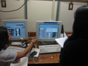
Below: Ally posing after assessing newly formed bathymetric (on the right) and side-scan sonar maps
In other news: if all goes according to plan (and so far we’re only 1 hour off Dan Fornari’s predicted schedule) we’ll start dredging on the 31st – just six days from today. We think we can speak for everyone when we say we are excited to get to the more hands-on work involved in dredging. The dredging should be especially cool as each of us (undergrads) will have the opportunity to plan our own dredge – including interpreting the maps to locate dredge sites, the logistics, and the (pseudo)management of the dredging operation.
Below: Ally and Angela analyzing side-scan sonar data
Above: The 4-8 watch team gathering around Dennis Geist while he discusses newly printed bathymetric and side-scan sonar maps
Soon we’ll be crossing the equator, and we Polliwogs are anxiously awaiting the formal crossing ceremony as preparations appear to be underway. Today we had to formally declare ourselves by signing our names on a sheet posted in the galley with green ink and, suspiciously enough, green-inked writing utensils have suddenly become a scarcity on the ship. And so it begins.
All in all, it’s been another great day on the Melville – great food, plenty of coffee and cool and interesting science. See you later!
Check out a new room post here!
Below: A beautiful sunset


No comments:
Post a Comment