Monday, May 31, 2010

Monday, May 31, 2010

We’ve been so busy today that it kind of feels like it’s been a week since we woke up this morning (or afternoon, depending on our watch), and it’s a little hard to figure out where to begin!
The 8-12 shift steps outside to enjoy the sunset together.
Since we have to start somewhere, this morning is as good a place as anywhere. At sunrise we found ourselves wrapping up the collection of our sonar data sandwiched between Pinta and Marchena Islands. After nearly two weeks of collecting data, we took the MR1 (side-scan sonar device) out of the water. Krista and Will watch anxiously as the MR1 is brought back in.

Reeling the several million dollar piece of equipment back to the ship is a bit of a stressful task as it is, which was not helped when we found out (just as the fish reached the surface) that there was a problem with the weight that held the machine’s front end down so that it wouldn’t smash into the ship at arrival.
The hook that attaches the weight properly was broken, making it hard to retrieve the fish.

After some serious deliberation and a joint decision made by the ship crew and the science party, a spare steel beam was found that could be used as a proxy for the faulty weight. Though there were a couple hair-raising moments, the beam did the trick, and the MR1 was successfully recovered to the relief of all those on board.After many trials, the MR1 is finally coming back on board!

Reeling in the MR1 “fish” signaled that dredging would finally begin, and our first dredge got underway this afternoon and has been memorable to say the least. Just north of Pinta Island, we aimed to dredge what appeared to be (from bathymetric maps) the farthest extent of a lava flow from Pinta. We may or may not have mentioned this before, but the winds in the region come primarily from the south. Since the ship only moves at about ¼ knot during dredging, we figured it would be a good idea to be facing into the wind as much as possible to avoid being blown off track. As we’re dredging from the ship’s starboard-side A-frame winch system, we had planned our dredges to comb the seafloor from west to east so the ship to stay pointing south. Unfortunately, strong currents in the area (possibly the result of being in such close proximity to Pinta Island) initially caused some headaches by pushing the ship off course and threatening to pull the dredge wire underneath the hull, which would not be good for the ship or the dredge wire. After some finagling, a safe course was set and the dredge continued smoothly.

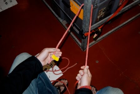
To make sure that the dredge was receiving “bites” on the seafloor, we monitored the tension of the dredge wire. A steady increase in the wire’s tension from, say 1,000 lbs to 2,200 lbs indicates that the dredge has caught onto something – preferably intact basalt – signaling the beginning of a bite. When the wire tension rapidly decreases from 2,200lbs to, say 800lbs, it hopefully indicates that whatever has caught the dredge has broken off, leaving us with several bits of good sample rocks to work with. While monitoring the tension this afternoon we definitely recorded a few bites, though nothing seemed particularly out of the ordinary. Will, Drew, and Ally secure tag lines to the dredge so it stays steady when it is brought up.

We hadn’t realized yet that we had snagged an extremely impressive rock sample, which had both the first-timers as well as the seasoned dredgers in a state of giddy excitement. A giant piece of intact pillow (“toothpaste”) lava that was too large to fit inside the dredge bag, the rock was caught precariously on the chain just above it.
Drew and the giant piece of lava as it comes up on the dredge.

Thanks to the deft maneuvering of Drew – one of the Res Techs, Denny, Dan, and the winch and crane operators, the rock was recovered and set aside (by crane) on the deck where it gathered a large crowd (pictures below).

Drew, Denny, and Dan securing the huge rock to a crane in order to move it.

Cheif scientist, Karen Harpp, and her prize catch!


Angela and Ally show off their muddy hands after sifting through piles of sediment brought up by the dredge.

It was an exhausting and exhilarating first day of dredging, and we’re hoping that the excitement of the first dredge continues through the next 39.

Eric poses with the large piece of lava.


Finally, for today's shout out of the day: Gretchen would like to send hugs and a big hello to her Mom, Dad, Buster, Mike, and any other family and friends reading this.
Gretchen saying hello to family and friends back home

Sunday, May 30, 2010

Sunday May 30, 2010

Above: This morning's beautiful sunrise

Isabela Looms,

Hazy sunset, waves, Blue feet,

Dredges upon us.

As we sit here at 7:02pm local time – 1:02am Zulu (the time we use for keeping records) – the main science lab is caught in a mild frenzy as preparations continue to be made in advance of the dredging that we will begin tomorrow morning.

Above: Karen Harpp and Eric Mittelstaedt enjoying the view

After enjoying an especially awesome sunset offshore of Pinta Island, with a cloud-capped view of Wolf Volcano on Isabela Island (the highest point in the Galapagos; epsilon Nd of +8, oooh) in the distance, we are now back at work in the lab measuring the last of the bathymetry, side-scan sonar, and gravity, making maps, and sorting out dredge plans. Unfortunately we are no longer collecting Mag data, as we discovered soon after dinner tonight that Maggie had crossed the MR1 wire, and needed to be brought up immediately. After a few tense moments, the Maggie was recovered successfully, and all is okay. Though we’d prefer to have it out and taking data, the situation could have been much worse.

Above: A view of Wolf Volcano on Isabela Island

In today’s science meeting we discussed the possibility of making watch changes for the dredging portion of the cruise (the final decision on whether that goes through is still pending) and listened to a presentation given by Miguel Calderón – one of the Ecuadorian scientists on the cruise – about his work for the Ecuadorian government in establishing official offshore territorial boundaries for diplomatic and economic purposes, including work in the Galapagos.

Above: The new route we took today. This track line extends across the survey area.

In other news, as we said before, we’re getting close to beginning the dredging process and are currently looping around Pinta and Marchena islands to collect some final bathymetric, side-scan, and gravity data. Final preparations for our days in port on Santa Cruz Island are also being made, and everyone is excited for tortoises, sea lions, and boobies.

Above: A red footed boobie

Above: Bud conducting an XBT

Check out this link [insert link here] for the latest crewmember interview with Brian Rowe, another of our awesome Res Techs.

Below: Alison(left) Karen(Middle) and Eric


Sunday, May 30th

The rest of today's entry will be posted soon, but for now here is a short video of two Red Footed Boobies flying over the bow of the ship:

Saturday, May 29, 2010

Saturday, May 29, 2010

Hello bloggers, today on the Melville was another warm and sunny day. Today during the science meeting we discussed the transition we will make from surveying with MR1 and bathymetry to the beginning of dredging. The MR1 side scan will be taken out of the water around 6pm on May 31. We will then start the dredging leg of our trip; beginning dredges the night of the 31st. Just before the dredging begins Dennis Geist will give a small talk on the procedures and protocol for sorting and storing the rocks collected from each dredge. This is very important because the last thing any of us want is to allow for the miss match of various dredge samples. Along with protocol we also learned how to tie a bowline knot, an essential knot to sailing, this will allow us to tie down the dredge while its on deck. As we begin our transit to Santa Cruz (an island in the central Galapagos archipelago), we will in fact cross the equator. Here on the Melville there are a large number of scientists and crewmembers who have never crossed the equator. There is a ceremony commemorating our first passage across this invisible line.

Here is an important skill we've learned so that we can tie off dredges: the bowline knot. Here is a step-by-step guide to tying it:

First, take a length of line, and pass it around an object you would like to tie the bowline around. Ensure that one end is shorter, the end that terminates, and the other has slack.

Create a loop in the side of the line that does not terminate. The end of the rope in the loop travelling towards the body of the author short be wrapped under the other end.

Pass the shorter line through the loop once.

Pass the end of the terminated line underneath the line coming towards your body from the loop.


Finally, take the end of line, and pass it back through the hole, and tighten the knot. There you have it, a bowline! It's a special knot that will not slip, but it also does not tighten under stress, making it easy to take out.

Finally, Will Schlitzer would like to congratulate his little brother, Sam, on graduating high school today!

Friday, May 28, 2010

May 29th 2010: Dredge Proposals

Hey faithful blog followers,

We’re drawing to the end of the mapping phase of our cruise (…and nearing the much-anticipated dredging phase! As geologists, we’re pretty excited about the promise of actual rocks.). We’ve only got two more days until we do some preliminary dredges before briefly disembarking and heading ashore for some land-based adventures. But before we can get the dredge in the water, we have to plan things out, and as the previous post noted, each student has received the task of planning a dredge of their very own.

The 4 - 8 shift likes to begin a stressful day of dredge planning with calming meditation. "See the dredge, be the dredge."

After a couple days of planning, today was the big day for some of the students who presented their dredge proposals in front of the council of elders! (They love it when we call them that…especially Eric.)


Will C. discusses his plans to dredge the seamount affectionately termed 'the Nubbin.' His shiftmates Ally and Angela planned dredges on the nearby round seamount colloquially known as 'the Cheerio.' Together they form the CNL (Cheerio-Nubbin lineament).


Cam discusses his dredge plans with the group while Dan and Ally look on.


The great Harppolini is unimpressed, even though Carbone provisionally named a giant caldera after her.


Karen, Dennis, Allison, and Eric enjoy the sunset out on deck.


The flamingo pose silhouetted against the sunset in honor of the officially named FLAMINGO cruise.


And here's today's

SHOUTOUT OF THE DAY!

Marques would like to give a big shoutout to his Dad and his bff Teddy Florence!

Also, don't forget to check out an interview with Chief Mate Chris over at the Crew Corner!

That's all for us on the Melville today. Don't forget to tune in tomorrow!

Thursday, May 27, 2010

May 27th, 2010

Hey folks

Today was just another beautiful day in paradise. We have been lucky enough to be able to smoothly collect data throughout the day as we come close to ending our twelfth pass through the region.
View from the boat

This data is being processed and will be used to decide the sites that we're going to dredge over the next couple of weeks. While the senior members of the science team will be picking most of these sites, undergrads and other members of the team will begin presenting their dredge proposals tomorrow. We are all waiting with bated breath to hear where Mike's "Bonesaw Dredge" will be.
Cait and Karen discussing Cait's dredge proposal

Will planning his dredge

After today's science meeting, Dan took us out to the quarter deck to show us exactly how the dredging process works. He, with the help of Drew and Brian, covered the assembly, deployment, and recovery of the dredge from start to finish. As we are going to be dealing with some very heavy equipment, Dan also spent a good deal of time stressing the safety measures that we have to take every time dredging is going on. We're hoping that we will be able to get in a handful of dredges before our brief trip ashore on the 3rd.

Drew and Dan preparing the dredge


Dan talking about the fundamentals of dredging


Marques, Cait and Ally preparing the dredge


When we finally do get to Santa Cruz there is going to be a lot for us to do. As we're going to have nearly 2 days on the island, we'll be able to enjoy activities such as scuba diving, snorkeling, taking a hike through the park, visiting the Charles Darwin Research Center, and relaxing at the beach. I think its safe to say that everyone on the ship is excited for this brief break from the cruise.

Check out today's interview with Dave here!
For more information on the MR1 sonar that we're using, click here


Shout out of the day!!!

The Wills would like to make a special shout out to their moms... and the rest of their family and friends as well!!!

Wednesday, May 26, 2010

May 26, 2010

Ahoy!

It is day 10 out to sea and things are beginning to pick up! It seems like everyone has settled into a nice routine, and people are getting excited about all the data we have collected and the anticipation of dredging. We have daily science meetings at 15:00 where we discuss the current data and look at the maps that were made the day before. Today we went over dredging, the techniques we will be using, what makes a good dredging site, and what the main goals of the trip are. We all get to design our very own dredge from start to finish! We even get to name them. There is a lot that goes into designing a dredge site.
Pictures of the A-frame we will be using to dredge

First we must select an area to focus on based on what geologic features are present and how these relate to our proposal. Once a well-defined focus area is established, including why we want to dredge in an area and exactly where we will dredge, a detailed map must be made using GMT. GMT is an intricate mapping program that uses various codes to produce detailed bathymetric maps of a designated area. The maps will cover anywhere from to 18 to 74 km2 of sea floor and will be printed on a large poster size piece of paper. We must also each give a 5 minute presentation trying to explain our dredging site to the rest of the group. These presentations must include a general description of the target area, longitude and latitude, water depth at the beginning and end of the dredge line, how it relates to the overall goal, estimated time of how long it will take from start to finish, and which direction the boat should point and exactly where to start. Most dredges take about 4 hours with another 2 hours to process the rocks and clean up for the next dredge. We will present our ideas on Friday so we have a lot to do!

Today each shift had to make a GMT map of a certain seamount in order to give us practice using the program.
Below is a picture of Mike Carbone’s map that he made for the 4-8 shift. We will each make a map like this when planning our dredging site. Along with looking at the maps more closely and comparing the bathymetry to the side-scan data, the watches have been keeping busy with some other tasks. One such task is scaring the sea birds off the ship when they land so they will not poop all over the boat.
Mike is especially good at this, and enjoys using a broom to scare them away. The 4am shift likes to start off their morning with some yoga in order to find their center and get their blood moving before interpreting data. All of the watches have seen some really cool seamounts and calderas and everyone is doing a really good job of interpreting the geologic features and how they may have come to be.

We are all taking full advantage of the sun while we are down here and you can find someone sunning on the bow of the boat at almost every hour. The hot tub has also been getting a lot of use.
A group gathers around the hot tub to hang out and watch the sunset.

The "man cave" enjoying the hot tub
There have also been lots of sightings of flying fish off the bow! We are all eagerly awaiting our arrival to the Galapagos Islands. Our estimated time of arrival is 7:00 am June 3rd. We will have the full day of the 3rd and a half-day on the 4th, we plan to leave port the afternoon of the 4th. Many trips are being planned while on the island, one is a snorkeling trip to Santa Fe Island, we will have a boat take us around to various snorkeling sights where we can see various fish and possibly sea lions and sharks. There is also a scuba diving trip for those who are certified. There is a trip to the highlands where wild finches and tortoises will be seen as well and a lava tube. A 7 km hike is another option for a short half day trip. Trips to the Charles Darwin Research Station will be going on, where you can learn about what is being done to conserve the islands as well as see some finches and tortoises, including Lonesome George, the only tortoise left of his species. If someone does not want to attend one of the several exciting trips, enjoying the beautiful landscape from the beach is a relaxing alternative.
Feel free to post questions and comments, we would love to hear from you!

One of the beautiful sunsets we have been lucky enough to enjoy.
For the newest installment of the Crew Corner, 3rd mate Jeff Kirby was interviewed, you can find the interview by clicking on the link below:

Tuesday, May 25, 2010

Tuesday, May 25, 2010

Above: This morning's sunrise

Another day in the Northern Galapagos – and over a week on the ship now – and everything is starting to become routine. Not routine as in boring or dull, but routine in the sense that everyone seems to be more confident in their watch duties and more comfortable with life at sea in general.

Above: A candid of Will Cushman watching the sun rise

This morning started with a bit of drama about halfway into the first watch (12-4 am). At about 2 am the crew monitoring the sonar data noticed that, even though the MR1 still seemed to be working and collecting data, the data weren’t being stored. After a quick frenzy, which involved calling almost the entire Hawai’i Mapping crew out of bed, the usually quiet graveyard shift became as lively as those at midday. The crew realized that the hard drive the data was being stored on was full, and no new data could be stored on it. Unfortunately, as a result, we lost a bit of sonar data before they could start storing it on another hard drive, but the loss was minimal.

In the way of good news, the magnetometer is back in the water and working well! Apparently the problem involved water somehow making its way into the cable that connects the mag to the ship that relays the data. Thanks to Brandi, the geophysics technician onboard, who slaved away for more than a day making repairs to the cable, “Maggie” is back in the water collecting data.

Above: The beautiful clouds from this morning

Today’s science meeting was action packed. We are now getting daily assignments to work on – both individually and in watch groups – that involve analyzing the bathymetric and sonar data we’ve collected so far. As a whole, we’re getting a lot better at recognizing features on the sonar maps, which are definitely a bit tricky to figure out to the untrained eye. Aside from making observations and developing basic interpretations of the maps, a couple watches went a little further and attempted to calculate the volumes of several seamounts, sedimentation rates, and differences between faults generated on either side of the Galapagos Spreading Center.

Below: Ally posing after assessing newly formed bathymetric (on the right) and side-scan sonar maps

In other news: if all goes according to plan (and so far we’re only 1 hour off Dan Fornari’s predicted schedule) we’ll start dredging on the 31st – just six days from today. We think we can speak for everyone when we say we are excited to get to the more hands-on work involved in dredging. The dredging should be especially cool as each of us (undergrads) will have the opportunity to plan our own dredge – including interpreting the maps to locate dredge sites, the logistics, and the (pseudo)management of the dredging operation.

Below: Ally and Angela analyzing side-scan sonar data

Above: The 4-8 watch team gathering around Dennis Geist while he discusses newly printed bathymetric and side-scan sonar maps

Soon we’ll be crossing the equator, and we Polliwogs are anxiously awaiting the formal crossing ceremony as preparations appear to be underway. Today we had to formally declare ourselves by signing our names on a sheet posted in the galley with green ink and, suspiciously enough, green-inked writing utensils have suddenly become a scarcity on the ship. And so it begins.

All in all, it’s been another great day on the Melville – great food, plenty of coffee and cool and interesting science. See you later!

Check out a new room post here!

Below: A beautiful sunset